| Godavari River | |
|---|---|
 | |
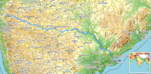
 Path of the Godavari through the South Indian Peninsula | |
| Location | |
| Country | India |
| State | Maharashtra, Telangana, Andhra Pradesh, Chhattisgarh, Odisha |
| Region | West India and South India |
| Physical characteristics | |
| Source | |
| • location | Brahmagiri Mountain, Trimbakeshwar, Nashik, Maharashtra, India |
| • coordinates | 19°55′48″N 73°31′39″E / 19.93000°N 73.52750°E |
| • elevation | 920 m (3,020 ft) |
| Mouth | Bay of Bengal |
• location | Antarvedi, Konaseema district Andhra Pradesh, India |
• coordinates | 17°0′N 81°48′E / 17.000°N 81.800°E[1] |
• elevation | 0 m (0 ft) |
| Length | 1,465 km (910 mi) |
| Basin size | 312,812 km2 (120,777 sq mi) |
| Discharge | |
| • location | Godavari Delta, Bay of Bengal |
| • average | 3,505 m3/s (123,800 cu ft/s) |
| Discharge | |
| • location | Rajahmundry (80 km upstream of mouth; Basin size: 308,946 km2 (119,285 sq mi)[2] |
| • average | (Period: 1998/01/01–2023/12/31)3,740.5 m3/s (132,090 cu ft/s)[2][3] |
| • minimum | 79 m3/s (2,800 cu ft/s)[3] |
| • maximum | 12,045 m3/s (425,400 cu ft/s)[3] |
| Discharge | |
| • location | Polavaram (1901–1979)[4] |
| • average | 3,061.18 m3/s (108,105 cu ft/s) |
| • minimum | 7 m3/s (250 cu ft/s) |
| • maximum | 34,606 m3/s (1,222,100 cu ft/s) |
| Basin features | |
| Tributaries | |
| • left | Banganga, Kadva, Shivana, Purna, Kadam, Pranahita, Indravati, Taliperu, Sabari |
| • right | Nasardi, Pravara, Sindphana, Manjira, Manair, Kinnerasani |
The Godavari (IAST: Godāvarī, [ɡod̪aːʋəɾiː]) is India's second longest river after the Ganga River and drains the third largest basin in India, covering about 10% of India's total geographical area.[5] Its source is in Trimbakeshwar, Nashik, Maharashtra.[6] It flows east for 1,465 kilometres (910 mi), draining the states of Maharashtra (48.6%), Telangana (18.8%), Andhra Pradesh (4.5%), Chhattisgarh (10.9%) and Odisha (5.7%). The river ultimately empties into the Bay of Bengal through an extensive network of distributaries.[7] Measuring up to 312,812 km2 (120,777 sq mi), it forms one of the largest river basins in the Indian subcontinent, with only the Ganga and Indus rivers having a larger drainage basin.[8] In terms of length, catchment area and discharge, the Godavari is the largest in peninsular India, and had been dubbed as the Dakshina Ganga (Southern Ganges).[9]
The river has been revered in Hindu scriptures for many millennia and continues to harbour and nourish a rich cultural heritage. In the past few decades, the river has been barricaded by several barrages and dams, keeping a head of water (depth) which lowers evaporation. Its broad river delta houses 729 persons/km2 – nearly twice the Indian average population density and has a substantial risk of flooding, which in lower parts would be exacerbated if the global sea level were to rise.[10][11]
- ^ Godāvari River at GEOnet Names Server
- ^ a b "River Discharge and Reservoir Storage Changes Using Satellite Microwave Radiometry".
- ^ a b c "The Flood Observatory".
- ^ "Sage River Database". Archived from the original on 21 June 2010. Retrieved 16 June 2011.
- ^ "The Godavari River System" (PDF). cwc.gov.in. Central Water Commission, Ministry of Jal Shakti, Department of Water Resources, River Development and Ganga Rejuvenation. Archived (PDF) from the original on 8 August 2021.
- ^ ""Godavari river basin map"" (PDF). Archived from the original (PDF) on 12 October 2013. Retrieved 2 November 2015.
- ^ "Integrated Hydrological DataBook (Non-Classified River Basins)" (PDF). Central Water Commission. p. 9. Archived from the original (PDF) on 4 March 2016. Retrieved 13 October 2015.
- ^ "Basins –". Archived from the original on 23 September 2015. Retrieved 12 October 2015.
- ^ "Dakshina Ganga (Ganga of South India) – River Godavari". Important India. 20 January 2014. Archived from the original on 18 January 2016. Retrieved 21 October 2015.
- ^ "Deltas at Risk" (PDF). International Geosphere-Biosphere Programme. Archived (PDF) from the original on 8 December 2015. Retrieved 21 May 2019.
- ^ South Asia Network on Dams Rivers and People (2014). "Shrinking and Sinking Deltas: Major role of Dams in delta subsidence and effective sea level rise" (PDF). Archived (PDF) from the original on 6 February 2016. Retrieved 15 January 2016.