This article includes a list of general references, but it lacks sufficient corresponding inline citations. (July 2013) |
You can help expand this article with text translated from the corresponding article in Finnish. (June 2023) Click [show] for important translation instructions.
|
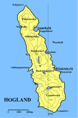
 Map of Hogland. The contour lines are drawn at 30-metre intervals. | |
| Administration | |
|---|---|
| Oblast | Leningrad Oblast |
| Additional information | |
| Time zone |
|


Gogland or Hogland (Russian: Гогланд, transliteration from original Swedish: Hogland; Finnish: Suursaari, German: Hochland) is an island in the Gulf of Finland in the eastern Baltic Sea, about 180 km west from Saint Petersburg and 35 km from the coast of Finland (near Kotka). Hogland has an area of approximately 21 km2 (8.1 sq mi); its highest point is 173 m (568 ft). It belongs to Russia's Kingiseppsky District in the Leningrad Oblast.
Gogland's tourist industry is growing in importance, with most tourists coming from St. Petersburg, and some from Finland. In 2006, however, Russian authorities declared Gogland a "border area", which means that foreign nationals are not allowed to travel to the island without special permits. This limits tourism from abroad to small groups, admitted one at a time, and adds extensive bureaucracy to applications for permission to visit the island.[citation needed]