Gol Municipality
Gol kommune | |
|---|---|
 | |
 Buskerud within Norway | |
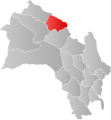
 Gol within Buskerud | |
| Coordinates: 60°45′1″N 8°59′5″E / 60.75028°N 8.98472°E | |
| Country | Norway |
| County | Buskerud |
| District | Hallingdal |
| Administrative centre | Gol |
| Government | |
| • Mayor (2003) | Jan-Halvard Brekko (Ap) |
| Area | |
• Total | 533 km2 (206 sq mi) |
| • Land | 514 km2 (198 sq mi) |
| • Rank | #200 in Norway |
| Population (2004) | |
• Total | 4,372 |
| • Rank | #218 in Norway |
| • Density | 8/km2 (20/sq mi) |
| • Change (10 years) | |
| Demonym | Goling[1] |
| Official language | |
| • Norwegian form | Nynorsk |
| Time zone | UTC+01:00 (CET) |
| • Summer (DST) | UTC+02:00 (CEST) |
| ISO 3166 code | NO-3324[3] |
| Website | Official website |
Gol () is a municipality in Buskerud county, Norway. It is part of the traditional region of Hallingdal. The administrative center of the municipality is the village of Gol which is also the population center. Gol was established as a municipality on 1 January 1838 (see formannskapsdistrikt). The area of Hemsedal was separated from Gol in 1897 to become a separate municipality. The municipality of Gol is bordered to the north by the municipality of Nord-Aurdal (in Oppland county), to the east by Sør-Aurdal (in Oppland county), to the south by Nes, and to the west by Ål and Hemsedal.[4]
- ^ "Navn på steder og personer: Innbyggjarnamn" (in Norwegian). Språkrådet.
- ^ "Forskrift om målvedtak i kommunar og fylkeskommunar" (in Norwegian). Lovdata.no.
- ^ Bolstad, Erik; Thorsnæs, Geir, eds. (2023-01-26). "Kommunenummer". Store norske leksikon (in Norwegian). Kunnskapsforlaget.
- ^ Geir Thorsnæs. "Gol". Store norske leksikon. Retrieved October 1, 2017.

