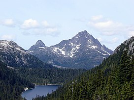
| Golden Hinde | |
|---|---|
 Golden Hinde, south aspect, August 2006. | |
| Highest point | |
| Elevation | 2,195 m (7,201 ft)[1] |
| Prominence | 2,195 m (7,201 ft)[1] |
| Listing | |
| Coordinates | 49°39′46″N 125°44′49″W / 49.66278°N 125.74694°W[2] |
| Geography | |
 | |
| Interactive map of Golden Hinde | |
| Location | Vancouver Island, British Columbia, Canada |
| District | Nootka Land District |
| Parent range | Vancouver Island Ranges |
| Topo map | NTS 92F12 Buttle Lake |
| Climbing | |
| First ascent | Einar Anderson, W.R. Kent 1913 or 1914 |
| Easiest route | rock climb |
The Golden Hinde is a mountain located in the Vancouver Island Ranges on Vancouver Island, British Columbia, Canada. At 2,195 metres (7,201 ft),[3] it is the highest peak on the island. The peak is popular with experienced backcountry-climbers, having been first ascended in 1913. The mountain is made of basalt which is part of the Karmutsen Formation.[4]
- ^ a b "British Columbia and Alberta: The Ultra-Prominence Page". Peaklist.org. Retrieved 2013-01-09.
- ^ "Golden Hinde, British Columbia". Peakbagger.com. Retrieved 2013-01-09.
- ^ Different sources list slightly different values for the maximum elevation above sea level. A recent survey using GPS determined the NAS83 elevation as 2,196.818 m. See "Golden Hinde". BC Geographical Names. for a discussion; see [1] for description of the trip to obtain this value
- ^ Geology of Strathcona Park - The Volcanic Flood Archived 2012-07-29 at archive.today Retrieved 24 November 2007

