Gongbo'gyamda County
工布江达县 • ཀོང་པོ་རྒྱ་མདའ་རྫོང་། | |
|---|---|
 Basum Tso | |
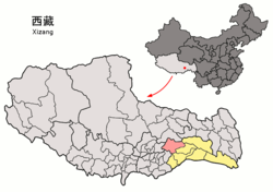
 Location of Gongbo'gyamda County (red) in Nyingchi City (yellow) and the Tibet Autonomous Region | |
| Coordinates: 30°23′38″N 93°27′10″E / 30.39389°N 93.45278°E | |
| Country | China |
| Autonomous region | Tibet |
| Prefecture-level city | Nyingchi |
| County seat | Gongbo'gyamda |
| Area | |
| • Total | 12,960.19 km2 (5,003.96 sq mi) |
| Population (2020)[1] | |
| • Total | 32,874 |
| • Density | 2.5/km2 (6.6/sq mi) |
| Time zone | UTC+8 (China Standard) |
| Website | www |
| Gongbo'gyamda County | |||||||
|---|---|---|---|---|---|---|---|
| Chinese name | |||||||
| Simplified Chinese | 工布江达县 | ||||||
| Traditional Chinese | 工布江達縣 | ||||||
| |||||||
| Tibetan name | |||||||
| Tibetan | ཀོང་པོ་རྒྱ་མདའ་རྫོང་། | ||||||
| |||||||
Gongbo'gyamda County (Tibetan: ཀོང་པོ་རྒྱ་མདའ་རྫོང; Chinese: 工布江达县) is a county of Nyingchi (or Nyingtri) City in the Tibet Autonomous Region, China lying approximately 275 km (171 mi) east of Lhasa at its central point. Its main geographical feature is Basum Tso, a green lake about 3,700 m (12,100 ft) above sea level.
- ^ "林芝市第七次全国人口普查主要数据公报" (in Chinese). Government of Nyingchi. 2021-06-17.

