Gooise Meren | |
|---|---|
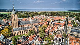
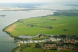
Bussum across from city hall Aerial view of the historic city of Naarden Aerial view of Muiden and Muiden Castle Dorpsstraat in Muiderberg | |
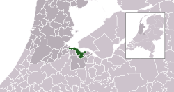
 Location in North Holland | |
| Coordinates: 52°17′00″N 5°10′00″E / 52.2833°N 5.1667°E | |
| Country | Netherlands |
| Province | North Holland |
| Region | Amsterdam metropolitan area |
| Established | 1 January 2016[1] |
| Government | |
| • Body | Municipal council |
| • Mayor | Han ter Heegde (VVD) |
| Area | |
• Total | 75.22 km2 (29.04 sq mi) |
| • Land | 41.59 km2 (16.06 sq mi) |
| • Water | 33.63 km2 (12.98 sq mi) |
| Population (January 2021)[4] | |
• Total | 58,524 |
| • Density | 1,407/km2 (3,640/sq mi) |
| Time zone | UTC+1 (CET) |
| • Summer (DST) | UTC+2 (CEST) |
| Postcode | 1398–1406, 1410–1414 |
| Area code | 0294, 035 |
| Website | gooisemeren |

Gooise Meren (pronounced [ˈɣoːisə ˈmeːrə(n)]) is a municipality in the province of North Holland, the Netherlands. It has about 58,000 inhabitants and covers an area of about 77 km2 (30 sq mi).
Gooise Meren has existed since 2016. It is a merger of the three former municipalities of Bussum, Muiden (including Muiderberg) and Naarden. Eastern (Naarden area) and southern part (Bussum area) of the municipality lie within the Gooi region, western part (Muiden area) lies within the Vechtstreek region.
The very northern part of the Utrecht Hill Ridge, lake Naardermeer and artificial island Pampus are situated within its boundaries.
Gooise Meren borders in the northwest on lake IJmeer, in the northeast on lake Gooimeer. The Vecht river empties into the IJmeer at Muiden, and also the northern end of the former Hollandic Water Line ends in Muiden.
- ^ "Gemeentelijke indeling op 1 januari 2016" [Municipal divisions on 1 January 2016]. cbs.nl (in Dutch). CBS. Retrieved 9 November 2018.
- ^ "Burgemeester Han ter Heegde" [Mayor Han ter Heegde] (in Dutch). Gemeente Gooise Meren. Archived from the original on 10 November 2018. Retrieved 9 November 2018.
- ^ "Kerncijfers wijken en buurten 2020" [Key figures for neighbourhoods 2020]. StatLine (in Dutch). CBS. 24 July 2020. Retrieved 19 September 2020.
- ^ "Bevolkingsontwikkeling; regio per maand" [Population growth; regions per month]. CBS Statline (in Dutch). CBS. 1 January 2021. Retrieved 2 January 2022.


