| Gooseneck | |
|---|---|
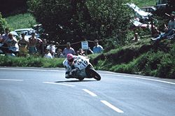
 Steve Hislop riding the rotary-engined Norton RCW 588 exiting the Gooseneck in 1992 | |
| Coordinates | 54°18′18.5″N 4°22′55.5″W / 54.305139°N 4.382083°W |
| Built | 1870, 1938-1939 |

Gooseneck, Isle of Man[1] (in Manx: Roan – the reddish land),[2] is an acute uphill right-bend on the Snaefell Mountain Course used for the TT motorcycle races between the 25th and 26th Milestone racing road-side markers, on the 37+ mile circuitous-course, measured from the startline at the TT Grandstand.
It is situated on the Snaefell Mountain Road, designated A18, a main two-way thoroughfare from Ramsey to Douglas with an adjacent side-road junction for the minor D28 Hibernia Road, in the parish of Maughold in the Isle of Man.
An historic location on the TT race course after the climb up from Ramsey demarking the end of the tree-line and start of the Mountain section with a height of 550 feet (168 metres) above sea level,[3] the Gooseneck is a popular vantage point for the spectators and a traditional signalling point for TT riders' intermediate race timings from their own back-up crews, one of a number of points around the course where the race machines slow enough to get a good look at the signal boards on the exit.[4] For the same reason, the location has always been popular with professional photographers and film-crews.
The Gooseneck is surrounded by open moorland and uncultivated grazing land of Park Mooar, the Rhowin and North Barrule in the Northern Uplands in the Isle of Man.[5]
- ^ Isle of Man Ramsey Courier page 2 22 May 1914 Motor Car Smashes - Tourist Trophy Races Exciting Incidents "....at the awkward bend in the Mountain Road, the scene of many 'spills' in the past and known as the Gooseneck, about a mile or so beyond the Hairpin Corner."
- ^ Place Names of the Isle of Man by John Kneen MA pp526 (1970) Yn Cheshaght Ghailckagh The Scolar Press
- ^ The Lucas contour map of the T.T. circuit, 1973. Accessed 21 December 2015
- ^ Motor Cycle 24 June 1965, p.843, [Image caption, Governor's Bridge/Glencrutchery Road]: "Jim Redman on his two-fifty Honda six howls past Derek Clarke, signalling at the end of lap 4, that Jim is about 110 seconds ahead of Mike Duff". Accessed 2015-06-26
- ^ Ramsey Courier page 1 24 April 1936 "Trespasses Notice - Any person trespassing on the Estates of Ballure (Reservoir), The Rhowin, Park Mooar or North Ballure, with gun, dog or ferret will be prosecuted. By Order"
