Gorman, California | |
|---|---|
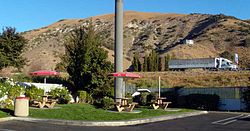
 Gorman, California, in 2008, from the west side of Interstate 5, which is marked by the white truck | |
 Location of Gorman in Los Angeles County, California | |
| Coordinates: 34°47′46″N 118°51′06″W / 34.79611°N 118.85167°W | |
| Country | |
| State | |
| County | Los Angeles |
| Area | |
• Total | 6.19169 km2 (2.390625 sq mi) |
| Elevation | 1,167 m (3,829 ft) |
| Time zone | UTC-8 (Pacific) |
| • Summer (DST) | UTC-7 (Pacific Daylight Time) |
| ZIP code | 93243 |
| Area code | 661 |
Gorman is an unincorporated community in northwestern Los Angeles County, California, United States. It is located in Peace Valley south of the Tejon Pass, which links Southern California with the San Joaquin Valley and Northern California. Due to this location, the area has served as a historic travel stop dating back to the indigenous peoples of California. Tens of thousands of motorists travel through Gorman daily on the Golden State Freeway (Interstate 5) since the highway's completion in the mid-20th Century.[1]
- ^ "Big Rig Overturns on Golden State Freeway in Gorman, SigAlert Issued". MyNewsLA.com. November 15, 2019. Retrieved April 14, 2020.


