| Gorokan Central Coast, New South Wales | |||||||||||||||
|---|---|---|---|---|---|---|---|---|---|---|---|---|---|---|---|
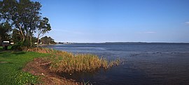
 Shore of Tuggerah Lake facing north | |||||||||||||||
 | |||||||||||||||
| Coordinates | 33°15′25″S 151°31′05″E / 33.257°S 151.518°E | ||||||||||||||
| Population | 8,367 (2016 census)[1] | ||||||||||||||
| • Density | 2,700/km2 (6,990/sq mi) | ||||||||||||||
| Postcode(s) | 2263 | ||||||||||||||
| Elevation | 10 m (33 ft) | ||||||||||||||
| Area | 3.1 km2 (1.2 sq mi) | ||||||||||||||
| Location |
| ||||||||||||||
| LGA(s) | Central Coast Council | ||||||||||||||
| Parish | Munmorah | ||||||||||||||
| State electorate(s) | Wyong | ||||||||||||||
| Federal division(s) | Dobell | ||||||||||||||
| |||||||||||||||
Gorokan (/ɡɔːrəkən/) is a suburb of the Central Coast region of New South Wales, Australia. Gorokan faces towards the Tuggerah Lake and the Budgewoi Lake on the western shores. It is part of the Central Coast Council local government area.
The word "Gorokan" means "The Morning Dawn" from the language of the Awabakal (an Aboriginal tribe). There are two schools in the area, Gorokan Public School and Gorokan High School.
- ^ Australian Bureau of Statistics (27 June 2017). "Gorokan (State Suburb)". 2016 Census QuickStats. Retrieved 16 June 2020.
