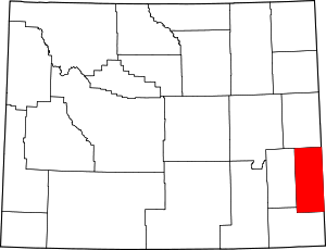
Goshen County | |
|---|---|
 | |
 Location within the U.S. state of Wyoming | |
 Wyoming's location within the U.S. | |
| Coordinates: 42°05′N 104°22′W / 42.09°N 104.36°W | |
| Country | |
| State | |
| Founded | February 21, 1911 (authorized) 1913 (organized) |
| Named for | Land of Goshen |
| Seat | Torrington |
| Largest city | Torrington |
| Area | |
| • Total | 2,232 sq mi (5,780 km2) |
| • Land | 2,225 sq mi (5,760 km2) |
| • Water | 6.8 sq mi (18 km2) 0.3% |
| Population (2020) | |
| • Total | 12,498 |
| • Density | 5.6/sq mi (2.2/km2) |
| Time zone | UTC−7 (Mountain) |
| • Summer (DST) | UTC−6 (MDT) |
| Congressional district | At-large |
| Website | goshencounty |
Goshen County (/ˈɡoʊʃən/, GOH-shən) is a county in the U.S. state of Wyoming. As of the 2020 United States Census, the population was 12,498.[1] Its county seat is Torrington.[2] The eastern boundary of the County borders the Nebraska state line.
Goshen County produces more cattle than any other Wyoming county. In 1997, the county had a total of 688 farms and ranches, averaging 1,840 acres. As of 2007, this had declined slightly to 665 farms and ranches in the county.[3]
- ^ "Goshen County, Wyoming". United States Census Bureau. Retrieved June 25, 2023.
- ^ "Find a County". National Association of Counties. Archived from the original on May 31, 2011. Retrieved June 7, 2011.
- ^ Zimmer, Vickie. "Goshen County WY". The Online Encyclopedia of Wyoming History. Wyoming State Historical Society. Archived from the original on March 26, 2013. Retrieved June 30, 2015.
{{cite encyclopedia}}:|website=ignored (help)
