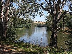
The Goulburn River, a major inland perennial river of the Goulburn Broken catchment, part of the Murray-Darling basin, is located in the Alpine, Northern Country/North Central, and Southern Riverina regions of the Australian state of Victoria. The headwaters of the Goulburn River rise in the western end of the Victorian Alps, below the peak of Corn Hill before descending to flow into the Murray River near Echuca, making it the longest river in Victoria at 654 kilometres (406 mi).[9] The river is impounded by the Eildon Dam to create Lake Eildon, the Eildon Pondage, the Goulburn Weir and Waranga Basin.
- ^ "Goulburn River: 2003: Historical Information". Vicnames. 12 August 2011. Archived from the original on 14 July 2014. Retrieved 13 July 2014.
- ^ "Goulburn River: 3776: Historical Information: Warring". 12 August 2011. Archived from the original on 14 July 2014. Retrieved 13 July 2014.
- ^ "Goulburn River: 3771: Historical Information: Koninner". 12 August 2011. Archived from the original on 14 July 2014. Retrieved 13 July 2014.
- ^ "Goulburn River: 3774: Historical Information: Gungupna". 12 August 2011. Archived from the original on 14 July 2014. Retrieved 13 July 2014.
- ^ "Goulburn River: 3773: Historical Information: Gaiyila". 12 August 2011. Archived from the original on 14 July 2014. Retrieved 13 July 2014.
- ^ "Goulburn River: 3775: Historical Information: Omio". 12 August 2011. Archived from the original on 14 July 2014. Retrieved 13 July 2014.
- ^ "Goulburn River: 3772: Historical Information: Bayyango". 12 August 2011. Archived from the original on 14 July 2014. Retrieved 13 July 2014.
- ^ "Map of Goulburn River". Bonzle Digital Atlas of Australia. Retrieved 22 June 2014.
- ^ "Goulburn River". Environment Victoria. Victorian Government. Retrieved 13 July 2014.

