Grafton, Wisconsin | |
|---|---|
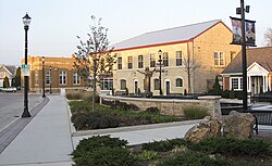
 Downtown Grafton, at the Paramount Plaza | |
 Location of Grafton in Ozaukee County, Wisconsin | |
| Coordinates: 43°19′9″N 87°55′54″W / 43.31917°N 87.93167°W | |
| Country | United States |
| State | Wisconsin |
| County | Ozaukee |
| Settled | 1839 |
| Incorporated | March 30, 1896 |
| Government | |
| • Village President | Daniel Delorit |
| • Administrator | Jesse Thyes |
| • Clerk | Kaity Olsen |
| • Village board | Trustees
|
| Area | |
• Total | 5.15 sq mi (13.34 km2) |
| • Land | 5.09 sq mi (13.18 km2) |
| • Water | 0.06 sq mi (0.16 km2) |
| Elevation | 709 ft (216 m) |
| Population | |
• Total | 12,094 |
• Estimate (2021)[4] | 12,298 |
| • Density | 2,302.48/sq mi (889.00/km2) |
| Time zone | UTC-6 (Central (CST)) |
| • Summer (DST) | UTC-5 (CDT) |
| ZIP code | 53024[5] |
| Area code | 262 |
| FIPS code | 55-30025[6] |
| GNIS feature ID | 1583294[2] |
| Website | village |
Grafton is a village in Ozaukee County, Wisconsin, United States. Located about 20 miles (32 km) north of Milwaukee and in close proximity to Interstate 43, it is a suburban community in the Milwaukee metropolitan area. The village incorporated in 1896, and at the time of the 2020 census the population was 12,094.
Like many of Ozaukee County's cities and villages, the Village of Grafton has rural roots and began as a mill town. The German and Irish immigrants who settled in Grafton in the 1840s utilized the Milwaukee River as a source of hydropower for gristmills and woolen mills. Manufacturing grew and prospered in the village in the 20th century, including the Paramount Records studio and plant, which was in Grafton from 1929 to 1935. Paramount was one of the first and largest producers of blues and jazz records marketed to African-American consumers.[7] Paramount's role in Grafton's history and Blues music history earned the village a spot on the historic Mississippi Blues Trail.[8]
Grafton changed significantly during the period of post-World War II suburbanization. Even though the last woolen mill closed in 1980, the village experienced rapid population growth and the development of new commercial properties and housing subdivisions. The construction of Interstate 43 in the mid-1960s eased travel to neighboring communities.[7] In the 21st century, Grafton is home to many big-box stores as well as an Aurora hospital.[9]
- ^ "2019 U.S. Gazetteer Files". United States Census Bureau. Retrieved August 7, 2020.
- ^ a b "US Board on Geographic Names". United States Geological Survey. October 25, 2007. Retrieved January 31, 2008.
- ^ Cite error: The named reference
wwwcensusgovwas invoked but never defined (see the help page). - ^ "Population and Housing Unit Estimates". United States Census Bureau. May 24, 2020. Retrieved May 27, 2020.
- ^ "Grafton WI ZIP Code". zipdatamaps.com. 2023. Retrieved February 10, 2023.
- ^ Cite error: The named reference
GR2was invoked but never defined (see the help page). - ^ a b Cite error: The named reference
Encyclopediawas invoked but never defined (see the help page). - ^ "Mississippi Blues Trail: Paramount Records". Mississippi Blues Commission. Retrieved January 1, 2020.
- ^ Cite error: The named reference
Jobswas invoked but never defined (see the help page).