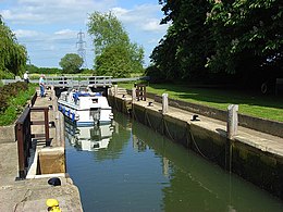
| Grafton Lock | |
|---|---|
 Grafton Lock | |
 | |
| Waterway | River Thames |
| County | Oxfordshire |
| Maintained by | Environment Agency |
| Operation | Manual |
| First built | 1896 |
| Length | 34.59 m (113 ft 6 in) [1] |
| Width | 4.59 m (15 ft 1 in)[1] |
| Fall | 1.11 m (3 ft 8 in)[1] |
| Above sea level | 223' |
| Distance to Teddington Lock | 118 miles |
Grafton Lock | |||||||||||||||||||||||||||||||||||||||||||||||||||||||||||||||||||||||||||||||||||||||||||||||||||||||||
|---|---|---|---|---|---|---|---|---|---|---|---|---|---|---|---|---|---|---|---|---|---|---|---|---|---|---|---|---|---|---|---|---|---|---|---|---|---|---|---|---|---|---|---|---|---|---|---|---|---|---|---|---|---|---|---|---|---|---|---|---|---|---|---|---|---|---|---|---|---|---|---|---|---|---|---|---|---|---|---|---|---|---|---|---|---|---|---|---|---|---|---|---|---|---|---|---|---|---|---|---|---|---|---|---|---|
| |||||||||||||||||||||||||||||||||||||||||||||||||||||||||||||||||||||||||||||||||||||||||||||||||||||||||
Grafton Lock is a lock on the River Thames in Oxfordshire, England. It is on the northern bank between Kelmscott and Radcot, about 1 mile (1.6 km) south of the hamlet of Grafton. The lock was built by the Thames Conservancy in 1896.
The weir is on the other side of the lock island at the upstream end.
Grafton Lock Meadow at the lock is a Site of Special Scientific Interest.
- ^ a b c "Environment Agency Dimensions of locks on the River Thames". web page. Environmental Agency. 8 November 2012. Retrieved 17 November 2012. Dimensions given in metres