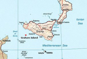
| Graham Island Isola Ferdinandea (Italian) Ile Julia (French) | |
|---|---|
 Approximate location of Graham Island | |
| Summit depth | Roughly 8 m (26 ft)[1] |
| Height | 63 m (207 ft) (maximum)[2] |
| Summit area | Campi Flegrei del Mar di Sicilia (Phlegraean Fields of the Sea of Sicily)[3] |
| Location | |
| Location | Between Sicily and Tunisia |
| Coordinates | 37°10′N 12°43′E / 37.167°N 12.717°E |
| Geology | |
| Type | Submarine volcano |
| Last eruption | 1863 |
Graham Island (also Graham Bank or Graham Shoal; Italian: Isola Ferdinandea; French: Île Julia) is a submarine volcano in the Mediterranean Sea near the island of Sicily that has, on more than one occasion, risen above the surface of the Mediterranean via volcanic action and soon thereafter been washed away. Since 300 BC this cycle of events has occurred four times.[4]
The top of the island is presently 6 metres below sea level. The island's most recent "appearance" occurred in July 1831, but then by January 1832 the portion of the island above sea level had been entirely washed away again by the wind and the waves of the Mediterranean Sea. The 1831 version of the island was first visited by the Sicilian customs official Michele Fiorini on 17 July 1831, who planted an oar there to claim the newly emerged island for the Kingdom of the Two Sicilies.[5]
On 2 August 1831 Humphrey Fleming Senhouse, the captain of the first rate Royal Navy ship of the line St Vincent named the island after Sir James Graham, the First Lord of the Admiralty, and claimed the island for the United Kingdom. In 1831, during the brief six-month lifespan of the island, a four-way dispute over the island's sovereignty arose, which was still unresolved when the island again disappeared beneath the waves in early 1832.
The island is a part of the underwater volcano Empedocles, 30 km (19 mi) south of Sicily, which is one of a number of submarine volcanoes known as the Campi Flegrei del Mar di Sicilia. Seamount eruptions have raised it above sea level several times before erosion submerged it again.
During its brief life in 1831, French geologist Constant Prévost was on hand, accompanied by an artist, to witness it in July; he named it Île Julia, for its July appearance, and reported in the Bulletin de la Société Géologique de France. Some observers at the time wondered if a chain of mountains would spring up, linking Sicily to Tunisia and thus upsetting the geopolitics of the region.[6] It showed signs of volcanic activity in 2000 and 2002, forecasting a possible appearance; however, as of 2016[update] it remains 6 m (20 ft) under sea level.
- ^ Cite error: The named reference
Maryann Birdwas invoked but never defined (see the help page). - ^ "Ferdinandea - The Disappeared Isle". Almanacco Siciliano. Accessed 11 February 2009.
- ^ Hedervári, Peter (1984). Catalog of Submarine Volcanoes and Hydrological Phenomena Associated with Volcanic Events, 1500 B.C. to December 31, 1899 (Report). Boulder, Colorado: National Geophysical Data Center. p. A2.
- ^ "Volcanic Island Could Rise After 170 Years Under Sea". New York Times. Reuters. 2002-11-26. Retrieved 2021-07-10.
- ^ Gallo, Emanuela (2005-09-24). "Ferdinandea: L'isola che non c'è (Ferdinandea: The island that no longer exists)". Supereva. Archived from the original on 2021-07-09. Retrieved 2021-07-08. Historical description of brief appearance of island.
- ^ Kozák, Jan; Cermák, Vladimir (2010). The Illustrated History of Natural Disasters. Dordrecht: Springer. p. 77. ISBN 978-9-04813-325-3.