Gramsbergen
Grambarge | |
|---|---|
Small city | |
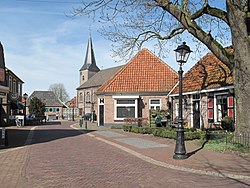
 Gramsbergen, view of the Kerkstraat | |
Location in province of Overijssel in the Netherlands | |
| Coordinates: 52°36′37″N 6°40′22″E / 52.61028°N 6.67278°E | |
| Country | Netherlands |
| Province | Overijssel |
| Municipality | Hardenberg |
| Area | |
• Total | 3.33 km2 (1.29 sq mi) |
| Elevation | 10 m (30 ft) |
| Population (2021)[1] | |
• Total | 3,180 |
| • Density | 950/km2 (2,500/sq mi) |
| Time zone | UTC+1 (CET) |
| • Summer (DST) | UTC+2 (CEST) |
| Postal code | 7783[1] |
| Dialing code | 0524 |
| Website | gramsbergen.nl |
Gramsbergen (Dutch Low Saxon: Grambarge) is a small Dutch city on the Vechte, located in the municipality of Hardenberg and the province of Overijssel. The town is located on corridors of different transportation modes: The N34 (Zwolle - Emmen), the Zwolle - Emmen railway and the Almelo - de Haandrik canal.
- ^ a b c "Kerncijfers wijken en buurten 2021". Central Bureau of Statistics. Retrieved 14 March 2022.
- ^ "Postcodetool for 7783AA". Actueel Hoogtebestand Nederland (in Dutch). Het Waterschapshuis. 24 July 2019. Retrieved 14 March 2022.


