Granada, Colorado | |
|---|---|
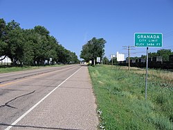
 Looking west on U.S. Highway 50/400 (2007) | |
 Location with Prowers County and Colorado | |
| Coordinates: 38°3′46.7″N 102°18′41.73″W / 38.062972°N 102.3115917°W[2] | |
| Country | United States |
| State | Colorado |
| County | Prowers[1] |
| Incorporated | July 25, 1887[3] |
| Area | |
• Total | 0.685 sq mi (1.775 km2) |
| • Land | 0.685 sq mi (1.775 km2) |
| • Water | 0 sq mi (0 km2) |
| Elevation | 3,484 ft (1,062 m) |
| Population | |
• Total | 445 |
| • Density | 650/sq mi (250/km2) |
| Time zone | UTC−7 (MST) |
| • Summer (DST) | UTC−6 (MDT) |
| ZIP Code[5] | 81041 |
| Area code | 719 |
| FIPS code | 08-31550 [2] |
| GNIS ID | 2412698 [2] |
| Website | Town Website |
Granada is a statutory town in Prowers County, Colorado, United States.[2][1] The town population was 445 at the 2020 United States Census.[4]
- ^ a b c "Active Colorado Municipalities". Colorado Department of Local Affairs. Retrieved October 18, 2021.
- ^ a b c d e "Granada, Colorado", Geographic Names Information System, United States Geological Survey, United States Department of the Interior
- ^ "Colorado Municipal Incorporations". State of Colorado, Department of Personnel & Administration, Colorado State Archives. December 1, 2004. Retrieved September 2, 2007.
- ^ a b c "Decennial Census P.L. 94-171 Redistricting Data". United States Census Bureau, United States Department of Commerce. August 12, 2021. Retrieved October 5, 2021.
- ^ "ZIP Code Lookup". United States Postal Service. Archived from the original (JavaScript/HTML) on November 4, 2010. Retrieved September 24, 2007.