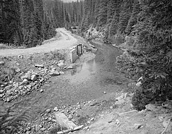
Grand River Ditch | |
 | |
| Nearest city | Grand Lake, Colorado |
|---|---|
| Coordinates | 40°27′34″N 105°51′01″W / 40.45944°N 105.85028°W |
| Area | 460 acres (1.9 km2) |
| Built | 1890 |
| Engineer | J.J. Argo |
| MPS | Rocky Mountain National Park MRA (AD) |
| NRHP reference No. | 76000218[1] |
| Added to NRHP | September 29, 1976 |
The Grand Ditch, also known as the Grand River Ditch and originally known as the North Grand River Ditch, is a water diversion project in the Never Summer Mountains, in northern Colorado in the United States. It is 14.3 miles (23.0 km) long, 20 feet (6.1 m) wide, and 3 feet (0.91 m) deep on average. Streams and creeks that flow from the highest peaks of the Never Summer Mountains are diverted into the ditch, which flows over the Continental Divide at La Poudre Pass at 10,175 feet (3,101 m), delivering the water into Long Draw Reservoir[2] and the Cache La Poudre River for eastern plains farmers. The water would otherwise have gone into the Colorado River (formerly known as the "Grand River", from which the name of the ditch is derived) that flows west towards the Pacific; instead, the Cache La Poudre River goes East and through the Mississippi River discharges into the Gulf of Mexico.
The ditch was started in 1890 and wasn't completed until 1936. The ditch diverts between 20 and 40% of the runoff from the Never Summer Mountains, and delivers an average of 20,000 acre-feet (25,000,000 m3). It significantly impacts the ecology in the valley below and the National Park Service has fought in court to reduce the amount of diverted water.[3][4]
- ^ "National Register Information System". National Register of Historic Places. National Park Service. July 9, 2010.
- ^ "Long Draw Reservoir - Public Lands History Center". publiclands.colostate.edu.
- ^ "Effects of the Grand Ditch (U.S. National Park Service)".
- ^ "Grand Ditch Breach Restoration Draft Environmental Impact Statement Released for Rocky Mountain National Park - Rocky Mountain National Park (U.S. National Park Service)".

