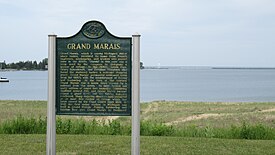
Grand Marais, Michigan | |
|---|---|
 | |
| Motto: Eastern Gateway to Pictured Rocks National Lakeshores[1] | |
 Location within Alger County | |
| Coordinates: 46°40′15″N 85°59′07″W / 46.67083°N 85.98528°W | |
| Country | |
| State | |
| County | |
| Township | Burt |
| Established | 1882 |
| Area | |
• Total | 3.24 sq mi (8.39 km2) |
| • Land | 1.89 sq mi (4.90 km2) |
| • Water | 1.35 sq mi (3.49 km2) |
| Elevation | 627 ft (191 m) |
| Population (2020) | |
• Total | 234 |
| • Density | 123.61/sq mi (47.73/km2) |
| Time zone | UTC-5 (Eastern (EST)) |
| • Summer (DST) | UTC-4 (EDT) |
| ZIP code(s) | 49839 |
| Area code | 906 |
| FIPS code | 26-33440 |
| GNIS feature ID | 627096[3] |
| Website | Chamber of Commerce |
| Grand Marais Informational Designation | |
|---|---|
 | |
| Location | Grand Marais, Michigan |
| Coordinates | 46°40′15.6″N 85°58′59.8″W / 46.671000°N 85.983278°W |
| Built | 1882 |
| Designated | August 14, 1962 |
Grand Marais (/ɡrændˈməˈreɪ/ grand mə-RAY) is an unincorporated community and census-designated place (CDP) in Alger County in the U.S. state of Michigan.[3] It is located within Burt Township on the shores of Lake Superior, and the community is the eastern gateway to the Pictured Rocks National Lakeshore via H-58.
- ^ "Grand Marais Chamber of Commerce website". Grand Marais Chamber of Commerce.
- ^ "2020 U.S. Gazetteer Files". United States Census Bureau. Retrieved May 21, 2022.
- ^ a b U.S. Geological Survey Geographic Names Information System: Grand Marais, Michigan

