| Granite Creek | |
|---|---|
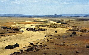
 Granite Creek in July | |
| Location | |
| Country | United States |
| State | Arizona |
| County | Yavapai |
| City | Prescott |
| Physical characteristics | |
| Source | Wolverton Mountain |
| • location | Bradshaw Mountains, Prescott National Forest |
| • coordinates | 34°29′58″N 112°30′34″W / 34.49944°N 112.50944°W[1] |
| • elevation | 6,292 ft (1,918 m)[2] |
| Mouth | Verde River |
• coordinates | 34°51′46″N 112°25′55″W / 34.86278°N 112.43194°W[1] |
• elevation | 4,236 ft (1,291 m)[1] |
| Length | 38 mi (61 km)[3] |
| Basin size | 359 sq mi (930 km2) |
| Discharge | |
| • location | 2 miles (3.2 km) north of Prescott[4] |
| • average | 7 cu ft/s (0.20 m3/s)[5] |
| • minimum | 0 cu ft/s (0 m3/s) |
| • maximum | 6,200 cu ft/s (180 m3/s) |
Granite Creek is a 38-mile (61 km) tributary of the Verde River in the U.S. state of Arizona.[3] It flows generally north-northeast from the Bradshaw Mountains of west-central Arizona through the city of Prescott and the Granite Dells to meet the river at the north end of the Little Chino Valley east of Sullivan Lake.[6]
- ^ a b c "Granite Creek". Geographic Names Information System. United States Geological Survey. February 8, 1980. Retrieved March 17, 2013.
- ^ Source elevation derived from Google Earth search using GNIS source coordinates.
- ^ a b Improvement Plan, p. 6
- ^ "Water-Data Report 2011: 09503000 Granite Creek Near Prescott, AZ" (PDF). U.S. Geological Survey. Retrieved March 18, 2013.
- ^ "Water-Data Report 2011: 09503000 Granite Creek Near Prescott, AZ" (PDF). U.S. Geological Survey. Retrieved March 18, 2013.
- ^ United States Geological Survey (USGS). "United States Geological Survey Topographic Map". TopoQuest. Retrieved March 17, 2013.
