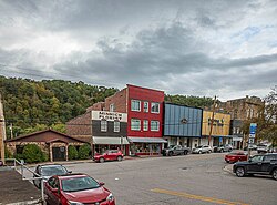
Grantsville, West Virginia | |
|---|---|
 Main St. Grantsville, WV 2023 | |
 Location of Grantsville in Calhoun County, West Virginia. | |
| Coordinates: 38°55′23″N 81°5′42″W / 38.92306°N 81.09500°W | |
| Country | United States |
| State | West Virginia |
| County | Calhoun |
| Area | |
| • Total | 0.46 sq mi (1.20 km2) |
| • Land | 0.43 sq mi (1.13 km2) |
| • Water | 0.03 sq mi (0.07 km2) |
| Elevation | 712 ft (217 m) |
| Population | |
| • Total | 482 |
| • Estimate (2021)[2] | 476 |
| • Density | 1,179.31/sq mi (455.18/km2) |
| Time zone | UTC-5 (Eastern (EST)) |
| • Summer (DST) | UTC-4 (EDT) |
| ZIP code | 26147 |
| Area code | 304 |
| FIPS code | 54-32884[3] |
| GNIS feature ID | 1539593[4] |
| Website | https://townofgrantsvillemunicipality.squarespace.com/ |

Grantsville is a town in Calhoun County, West Virginia, United States. The population was 482 at the 2020 census.[2] It is the county seat of Calhoun County.[5] The town was established along the Little Kanawha River[6] in 1865 and named for Ulysses S. Grant.[7][8] Grantsville is home to Wayne Underwood Park, which includes a .25-mile-long (0.40 km) walking trail, and to the annual West Virginia Wood Festival.
- ^ "2019 U.S. Gazetteer Files". United States Census Bureau. Retrieved August 7, 2020.
- ^ a b c Bureau, US Census. "City and Town Population Totals: 2020-2021". Census.gov. US Census Bureau. Retrieved July 3, 2022.
{{cite web}}:|last1=has generic name (help) - ^ "U.S. Census website". United States Census Bureau. Retrieved January 31, 2008.
- ^ "US Board on Geographic Names". United States Geological Survey. October 25, 2007. Retrieved January 31, 2008.
- ^ "Find a County". National Association of Counties. Archived from the original on May 31, 2011. Retrieved June 7, 2011.
- ^ West Virginia Atlas & Gazetteer. Yarmouth, Me.: DeLorme. 1997. p. 34. ISBN 0-89933-246-3.
- ^ Kenny, Hamill (1945). West Virginia Place Names: Their Origin and Meaning, Including the Nomenclature of the Streams and Mountains. Piedmont, West Virginia: The Place Name Press. p. 280.
- ^ Gannett, Henry (1905). The Origin of Certain Place Names in the United States. Govt. Print. Off. pp. 142.