| Grayshott | |
|---|---|
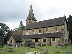
 Parish church of St Luke | |
Location within Hampshire | |
| Population | 2,413 (2011 Census)[1] |
| OS grid reference | SU872353 |
| Civil parish |
|
| District | |
| Shire county | |
| Region | |
| Country | England |
| Sovereign state | United Kingdom |
| Post town | Hindhead |
| Postcode district | GU26 |
| Police | Hampshire and Isle of Wight |
| Fire | Hampshire and Isle of Wight |
| Ambulance | South Central |
| UK Parliament | |
Grayshott is a village and civil parish in the East Hampshire district of Hampshire, England. It is on the Hampshire / Surrey border 4 miles (6.4 km) northwest of Haslemere by road, and 46 miles (74 km) southwest of central London. The nearest rail link is Haslemere railway station.
The present village consists of houses and shops on either side of the B3002 Headley Road, which leads from the A333 at Hindhead to Headley Down, Headley and Bordon, and Crossways Road which runs south east from the centre of the village. East of the village centre, joining these two roads, is Boundary Road, which marks the boundary between Hampshire and Surrey.
Originally, the name referred to a hamlet a mile west of the present village.
Grayshott was part of Headley parish until 1901 (ecclesiastical parish) and 1902 (civil parish). The present civil parish is part of East Hampshire District.
- ^ "Civil Parish population 2011". Neighbourhood Statistics. Office for National Statistics. Archived from the original on 23 December 2016. Retrieved 18 December 2016.
