| Great Australian Bight | |
|---|---|
 Coastline of the Great Australian Bight | |
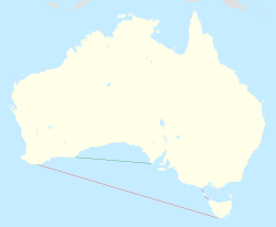
 Limits of the Great Australian Bight (in red as defined by the International Hydrographic Organization, in green by the Australian Hydrographic Service). | |
| Location | South Australia, Tasmania, Victoria, Western Australia |
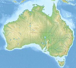
| Coordinates | 33°S 130°E / 33°S 130°E[1][2] |
| Type | Oceanic bight |
| Primary outflows | Indian Ocean (in Australia, considered part of the Southern Ocean) |
| Basin countries | Australia |
| Surface area | 45,926 km2 (17,732 sq mi) |
The Great Australian Bight is a large oceanic bight, or open bay, off the central and western portions of the southern coastline of mainland Australia.
There are two definitions for its extent—one by the International Hydrographic Organization (IHO) and another by the Australian Hydrographic Service (AHS). The bight is generally considered part of the Indian Ocean, although the AHS classifies it as part of the Southern Ocean. Its coastline is characterized by cliff faces and rocky capes, making it an ideal location for whale-watching.
This oceanic feature was first encountered by European explorers in 1627, and was accurately charted by English navigator Matthew Flinders in 1802. The Great Australian Bight came into existence about 50 million years ago when the supercontinent Gondwana broke apart, separating Antarctica from Australia.
The Bight's waters are highly biodiverse, especially in zooplankton, due to specific ocean currents. However, more research is needed to fully understand the region's complex ecosystems and the potential impacts of human activities, such as resource extraction. Southern bluefin tuna are a popular fishing target in the Bight, and there have been attempts to explore the area for oil and gas since the 1960s. However, these proposals have faced significant opposition due to the potential environmental impacts.
- ^ "Great Australian Bight (WA)". Gazetteer of Australia online. Geoscience Australia, Australian Government.
- ^ "Great Australian Bight (SA)". Gazetteer of Australia online. Geoscience Australia, Australian Government.
