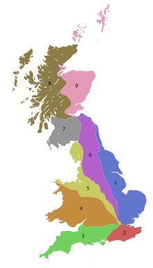
In Great Britain, there is a numbering scheme used to classify and identify all roads. Each road is given a single letter (representing a category) and a subsequent number (between one and four digits). Though this scheme was introduced merely to simplify funding allocations, it soon became used on maps and as a method of navigation. There are two sub-schemes in use: one for motorways, and another for non-motorway roads.
While some of Great Britain's major roads form part of the international E-road network, no E-routes are signposted in the United Kingdom. Due to changes in local road designation, in some cases roads are numbered out of zone. There are also instances where two unrelated roads have been given exactly the same number; for example, the Leicester Ring Road and a road in Cumbria are both designated A594.
This scheme applies only to England, Scotland and Wales; a separate system using similar conventions is used in Northern Ireland, as well as outside the United Kingdom in the Isle of Man, Jersey and British Overseas Territories.