| Great Lakes Council New South Wales | |||||||||||||||
|---|---|---|---|---|---|---|---|---|---|---|---|---|---|---|---|
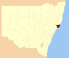
 Location in New South Wales | |||||||||||||||
| Coordinates | 32°13′S 152°32′E / 32.217°S 152.533°E | ||||||||||||||
| Population | 34,430 (2011 census)[1] | ||||||||||||||
| • Density | 10.1985/km2 (26.414/sq mi) | ||||||||||||||
| Established | 7 March 1906 | ||||||||||||||
| Abolished | 12 May 2016 | ||||||||||||||
| Area | 3,376 km2 (1,303.5 sq mi) | ||||||||||||||
| Time zone | AEST (UTC+10) | ||||||||||||||
| • Summer (DST) | AEDT (UTC+11) | ||||||||||||||
| Mayor | Jan McWilliams[2] | ||||||||||||||
| Council seat | Forster | ||||||||||||||
| Region | Mid North Coast[3] | ||||||||||||||
| State electorate(s) | |||||||||||||||
| Federal division(s) | Paterson[7] | ||||||||||||||
| Website | Great Lakes Council | ||||||||||||||
| |||||||||||||||
Great Lakes Council was a local government area in the Mid North Coast region of New South Wales, Australia. The area is situated adjacent to the shores of Port Stephens, Myall Lakes and Wallis Lake and the Pacific Highway and the Lakes Way. On 12 May 2016 the council was dissolved and the area included in the Mid-Coast Council, along with the City of Greater Taree and Gloucester Shire.[8]
The Great Lakes area is home to the globally significant, Ramsar Convention listed Myall Lakes wetlands. These wetlands are an important foundation for the economies of the former suburbs of the Great Lakes Council local government area, particularly the recreational fisheries and tourism sectors.[citation needed]
- ^ Australian Bureau of Statistics (31 October 2012). "Great Lakes (Local Government Area)". 2011 Census QuickStats. Retrieved 10 September 2012.
- ^ "Council Search – Great Lakes Council". New South Wales Division of Local Government. Retrieved 4 October 2012.
- ^ "Suburb Search – Local Council Boundaries – Hunter (HT) – Great Lakes Council". New South Wales Division of Local Government. Archived from the original on 16 January 2013. Retrieved 3 October 2012.
- ^ "Myall Lakes". New South Wales Electoral Commission. Retrieved 23 November 2019.
- ^ "Upper Hunter". New South Wales Electoral Commission. Retrieved 23 November 2019.
- ^ "Port Stephens". New South Wales Electoral Commission. Retrieved 23 November 2019.
- ^ "Paterson". Australian Electoral Commission. 26 July 2012. Archived from the original on 29 October 2009. Retrieved 3 October 2012.
- ^ "Mid-Coast Council". Stronger Councils. Government of New South Wales. 12 May 2016. Retrieved 20 May 2016.