| Great Whale River | |
|---|---|
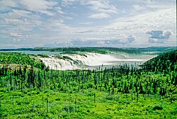
 The first step of the GB1 falls of Great Whale River, Summer 1992 | |
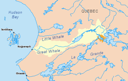
 Great Whale River basin in yellow | |
| Native name |
|
| Location | |
| Country | Canada |
| Province | Quebec |
| Region | Nunavik |
| Physical characteristics | |
| Source | Lake Saint-Luson |
| • coordinates | 54°49′30″N 70°32′17″W / 54.82500°N 70.53806°W |
| • elevation | 500 m (1,600 ft) |
| Mouth | Hudson Bay |
• location | Kuujjuarapik / Whapmagoostui |
• coordinates | 55°15′59″N 77°47′23″W / 55.26639°N 77.78972°W |
• elevation | 0 m (0 ft) |
| Length | 724 km (450 mi)[1] |
| Basin size | 42,700 km2 (16,500 sq mi)[1] |
| Discharge | |
| • average | 680 m3/s (24,000 cu ft/s)[1] |
The Great Whale River (French: Grande rivière de la Baleine) is a river in Nunavik, Quebec, Canada. It flows from Lac Saint-Luson through Lac Bienville west to Hudson Bay. While the lower section of the river (after Lac Bienville) has a very powerful current, with many waterfalls (up to 15 metres (49 ft) or 20 metres (66 ft) in height) and rapids, the upper section consists of a series of lakes interconnected by steep rapids and ledges.
Great Whale River also has a branch originating from Caniapiscau Reservoir. For canoeists, this is the easiest access (a bridge on the Trans-Taiga Road at Lac Montausier 54°43′53.41″N 70°11′45.24″W / 54.7315028°N 70.1959000°W).
Both the northern village of Kuujjuarapik, whose inhabitants are mostly Inuit, and the Cree village of Whapmagoostui are situated at the mouth of the river, near the site of the former RCAF Station Great Whale River. The villages were formerly known collectively as "Great Whale River" and "Poste-de-la-Baleine."
The portion between Lake Bienville and the mouth of the Coats River has also been called Abchigamich River, but this name was dropped in 1946 by the Commission de géographie du Québec. Also, the name has often been wrongly translated into French as Rivière de la Grande Baleine (not until 1962 did the Commission de géographie du Québec officially adopt the current Grande rivière de la Baleine).[2]
- ^ a b c Atlas of Canada Archived 2007-04-04 at the Wayback Machine
- ^ Cite error: The named reference
CTQ-GBwas invoked but never defined (see the help page).