Green Harbor-Cedar Crest | |
|---|---|
Former census-designated place | |
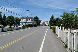
 Bay Avenue in Green Harbor | |
| Coordinates: 42°4′29″N 70°39′30″W / 42.07472°N 70.65833°W | |
| Country | United States |
| State | Massachusetts |
| County | Plymouth |
| Towns | Duxbury Marshfield |
| Area | |
• Total | 1.9 sq mi (5.0 km2) |
| • Land | 1.8 sq mi (4.6 km2) |
| • Water | 0.2 sq mi (0.4 km2) |
| Population (2010) | |
• Total | 2,609 |
| • Density | 1,400/sq mi (520/km2) |
| Time zone | UTC-5 (Eastern (EST)) |
| • Summer (DST) | UTC-4 (EDT) |
| ZIP code | |
| Area code | 339 / 781 |
| FIPS code | 25-27147 |
Green Harbor-Cedar Crest was a census-designated place (CDP) in the towns of Duxbury and Marshfield in Plymouth County, United States. It included the village of Green Harbor, on the shore of Massachusetts Bay, and the community of Cedar Crest, occupying a hill on the north side of Careswell Street. The population of the CDP was 2,609 at the 2010 census.[2] Prior to the 2020 census the area was split into two CDPs, Green Harbor and Cedar Crest.
- ^ "Zipcode 02041 Map". Retrieved January 25, 2019.
- ^ "Profile of General Population and Housing Characteristics: 2010 Demographic Profile Data (DP-1): Green Harbor-Cedar Crest CDP, Massachusetts". United States Census Bureau. Retrieved March 22, 2012.

