Green Valley | |
|---|---|
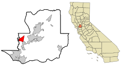
 Location in Solano County and the state of California | |
| Coordinates: 38°15′34″N 122°9′52″W / 38.25944°N 122.16444°W | |
| Country | United States |
| State | California |
| County | Solano |
| Government | |
| • State Senator | Bill Dodd (D)[1] |
| • CA Assembly | Lori Wilson (D)[2] |
| • U. S. Rep. | John Garamendi (D)[3] |
| Area | |
| • Total | 8.309 sq mi (21.522 km2) |
| • Land | 8.308 sq mi (21.519 km2) |
| • Water | 0.001 sq mi (0.004 km2) 0.02% |
| Elevation | 115 ft (35 m) |
| Population (2010) | |
| • Total | 1,625 |
| • Density | 200/sq mi (76/km2) |
| Time zone | UTC-8 (PST) |
| • Summer (DST) | UTC-7 (PDT) |
| ZIP code | 94534 |
| Area code | 707 |
| FIPS code | 06-31099 |
| GNIS feature ID | 1853394 |
Green Valley is a census-designated place (CDP) located in Solano County, California, United States. It sits in the northeast corner of the San Francisco Bay Area and is located approximately 45 miles (72 km) from Sacramento, approximately 38 miles (61 km) from San Francisco, approximately 32 miles (51 km) from Oakland, less than 15 miles (24 km) from Napa Valley, and less than 15 miles (24 km) from both the Carquinez Bridge and the Benicia Bridge.
The use of "Green Valley" as a place name predates the CDP designation by over a century; a Green Valley Township appears on an 1890 map of Solano County.[5]
The population was 1,654 at the 2020 census.
- ^ "Statewide Database". UC Regents. Archived from the original on February 1, 2015. Retrieved December 5, 2014.
- ^ "Legislative Districts in California". CA State Geoportal. Retrieved June 18, 2024.
- ^ "Legislative Districts in California". CA State Geoportal. Retrieved June 18, 2024.
- ^ "2010 Census U.S. Gazetteer Files – Places – California". United States Census Bureau.
- ^ Vincent Verga; Ray Jones (2010). California: Mapping the Golden State Through History. Morris Book Publishing. p. 54. ISBN 978-0-7627-4530-2.
