| Greenbelt (Ottawa) | |
|---|---|
 | |
 Map of Ottawa showing the Greenbelt surrounding the urban core | |
| Location | Eastern Ontario, Canada |
| Nearest city | Ottawa |
| Area | 203.5 km2 (78.6 sq mi) |
| Established | 1956 |
| Governing body | National Capital Commission |
| ncc-ccn | |
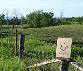
The Greenbelt is a 203.5-square-kilometre (78.6 sq mi) protected green belt traversing Ottawa, Ontario, Canada. It includes green space, forests, farms, and wetlands from Shirleys Bay in the west and to Green's Creek in the east.[1] It is the largest publicly owned green belt in the world[2] and the most ecologically diverse area in Eastern Ontario.[3] The National Capital Commission (NCC) owns and manages 149.5 square kilometres (57.7 sq mi), and the rest is held by other federal government departments and private interests.[1] Real estate development within the Greenbelt is strictly controlled.[citation needed]
The Greenbelt lies within eight kilometers of Parliament Hill in downtown Ottawa and ranges in width from two to ten kilometers. It encircles many of the oldest communities in the City of Ottawa, and covers the same amount of land as the urbanized area of Ottawa that it surrounds.[4]
- ^ a b Cite error: The named reference
GHCwas invoked but never defined (see the help page). - ^ "Greenbelt". National Capital Commission. Retrieved 2022-06-26.
- ^ "Conservation and scientific research in the Greenbelt". National Capital Commission. Retrieved 2022-06-26.
- ^ SENES Consultants Limited (2014). Canada's capital greenbelt master plan. National Capital Commission. p. V. ISBN 978-1-100-23179-2. Retrieved 2022-06-26.