This article needs additional citations for verification. (February 2011) |
Greenisland
| |
|---|---|
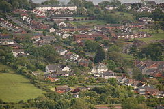
 Greenisland, as viewed from the Knockagh Monument | |
Location within Northern Ireland | |
| Population | 5,486 (2011 Census) |
| District | |
| County | |
| Country | Northern Ireland |
| Sovereign state | United Kingdom |
| Post town | CARRICKFERGUS |
| Postcode district | BT38 |
| Dialling code | 028 |
| UK Parliament | |
Greenisland (Irish: Inis Glas[1]) is a town in County Antrim, Northern Ireland. It lies 7 miles north-east of Belfast and 3 miles south-west of Carrickfergus. The town is on the coast of Belfast Lough and is named after a tiny islet to the west, the Green Island.[2]
It is a semi-rural[citation needed] community located at the foot of Carn Hill , upon which stands the Knockagh Monument, a war memorial for those from County Antrim who died in the first and second world wars.[3]
The town has two distinct areas, known locally as Upper Greenisland and Lower Greenisland after the upper Station Road and lower Station Road around which two parts are respectively located.[citation needed] Upper Greenisland stretches from Upper Road (B90) to the railway station at the bottom of Upper Station Road, includes Greenisland Primary School and features predominantly middle-class demographics and housing. Lower Greenisland runs from the railway station, down Station Road and ends at Shore Road (part of the A2 road). It features a large, predominantly Protestant working-class housing estate built during the 1950s and 1960s[4] and includes Greenisland Library, Greenisland Community Centre, a number of churches, a small shopping parade at Glassillan Court and Silverstream Primary School. The village in its entirety stretches from the foot of the hill to the shore of Belfast Lough.
- ^ "Inis Glas/Green Island". logainm.ie. Retrieved 27 March 2023.
- ^ http://www.betweentheknockaghandthelough.co.uk/HistoricalOverview.aspx[permanent dead link] Between the Knockagh and the Lough: Historical Overview
- ^ "Discover Ireland | Knockagh Monument. Carrickfergus, Antrim, Northern Ireland". Archived from the original on 28 March 2012. Retrieved 2 February 2011. Discover Ireland: The Knockagh Monument
- ^ http://www.betweentheknockaghandthelough.co.uk/PresentDay.aspx[permanent dead link] Between the Knockagh and the Lough: Present Day
