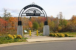
| Greenlink Rotary Park Trail System | |
|---|---|
 Maillard Street Entrance | |
 | |
| Type | Municipal Urban Park |
| Location | Cape Breton Island, Nova Scotia, Canada |
| Nearest town | Sydney |
| Coordinates | 46°07′18″N 60°10′55″W / 46.121570°N 60.181983°W |
| Area | 52 acres (21 ha) |
| Created | 15 August 1956 |
| Operated by | Cape Breton Regional Municipality, Parks & Grounds |
| Status | Operational |
| Hiking trails | Greenlink Trails |
| Public transit access | Transit Cape Breton Route 13 |
| Website | Rotary Park |
Greenlink Rotary Park Trail System is a Canadian urban park located in the community of Sydney, part of Nova Scotia's Cape Breton Regional Municipality. The park incorporates the Greenlink Trail System, the Rotary Park Off Leash Park, as well as a disc golf course. Much of the park is forested, with ponds, a stone dam, and streams in the valleys; a few acres are open lawn area, suitable for informal recreation. The park encompass 52 acres (21 ha) within the former city's boundaries.
The trail system connects Sydney's Shipyard and South End neighbourhoods to Membertou First Nation and the Cape Breton Regional Hospital.[1][2] Two of the trails progress from Shandwick Street and the St. Anthony Daniel Ball Park, with both trails converging with the trail from Rotary Drive, crossing Churchill Drive, and extending to the Cape Breton Regional Hospital property.
- ^ Cite error: The named reference
Outdoorwas invoked but never defined (see the help page). - ^ "CBRM tender for Greenlink Trail closes on Sept. 12". Cape Breton Post. SaltWire Network. 5 September 2019. Retrieved 2 May 2020.