Greenwald | |
|---|---|
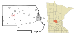
 Location of Greenwald within Stearns County, Minnesota | |
| Coordinates: 45°36′N 94°52′W / 45.600°N 94.867°W | |
| Country | United States |
| State | Minnesota |
| County | Stearns |
| Area | |
• Total | 0.71 sq mi (1.85 km2) |
| • Land | 0.71 sq mi (1.85 km2) |
| • Water | 0.00 sq mi (0.00 km2) |
| Elevation | 1,266 ft (386 m) |
| Population (2020) | |
• Total | 197 |
| • Density | 276.30/sq mi (106.72/km2) |
| Time zone | UTC-6 (Central (CST)) |
| • Summer (DST) | UTC-5 (CDT) |
| ZIP code | 56335 |
| Area code | 320 |
| FIPS code | 27-25874[3] |
| GNIS feature ID | 2394998[2] |
Greenwald is a city in Stearns County, Minnesota, United States. The population was 222 at the 2010 census.[4] It is part of the St. Cloud Metropolitan Statistical Area.
Minnesota State Highway 4 serves as a main route in the community and Interstate 94 passes nearby.
- ^ "2020 U.S. Gazetteer Files". United States Census Bureau. Retrieved July 24, 2022.
- ^ a b U.S. Geological Survey Geographic Names Information System: Greenwald, Minnesota
- ^ "U.S. Census website". United States Census Bureau. Retrieved January 31, 2008.
- ^ "2010 Census Redistricting Data (Public Law 94-171) Summary File". American FactFinder. U.S. Census Bureau, 2010 Census. Retrieved April 23, 2011.[dead link]