| Gribskov | |
|---|---|
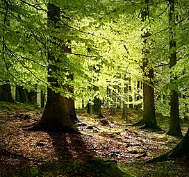
 Old beech trees in Gribskov. | |
| Map | |
| Geography | |
| Location | Hillerød, Helsinge, Fredensborg, Denmark |
| Coordinates | 55°59′N 12°18′E / 55.983°N 12.300°E |
| Area | 56 km2 (22 sq mi) |
| Ecology | |
| WWF Classification | Baltic mixed forests |
Gribskov (Grib Forest) is Denmark's fourth largest forest,[1] comprising c. 5,600 ha of woodland situated in northern Zealand, west and south of Lake Esrum. The forest is owned and administered by the State of Denmark, and a part of the Kongernes Nordsjælland National Park.[2] In July 2015, it was one of three forests included in a UNESCO World Heritage Site, the Par force hunting landscape in North Zealand.[3]
Gribskov is usually divided into four sections: The northwest surrounding the small village of Maarum, the northeast on the banks of Lake Esrum, the southwest around the small lake of Gribsø and finally the southeast, enclosing the village of Nødebo on the southern banks of Lake Esrum.
Only a thin strip of Hillerød town in the south separates Gribskov from many larger woodlands such as Store Dyrehave at 1,100 ha, Tokkekøb Hegn at 631 ha and several smaller woods.[4][5]
- ^ Denmark's 10 largest forests Archived 2012-03-08 at the Wayback Machine The Danish Wood Initiative (2004)
- ^ "Om Kongernes Nordsjælland" (in Danish). kongernes-nordsjælland.dk. 23 May 2018. Retrieved 29 May 2018.[permanent dead link]
- ^ "Sites in Denmark, France and Turkey inscribed on UNESCO's World Heritage List". unesco.org. UNESCO. 4 July 2015. Retrieved 17 July 2015.
- ^ Store Dyrehave Gydendals Open Encyclopedia (in Danish)
- ^ Tokkekøb Hegn Danish Nature Agency (in Danish)
