| Gros Morne National Park | |
|---|---|
| Parc national du Gros-Morne | |
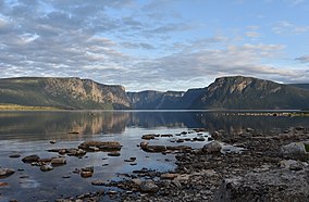
 Western Brook Pond in Gros Morne National Park | |
Location in Canada Location in Newfoundland | |
| Location | Rocky Harbour, Newfoundland and Labrador, Canada |
| Coordinates | 49°41′22″N 57°44′17″W / 49.68944°N 57.73806°W |
| Area | 1,805 km2 (697 sq mi) |
| Established | October 1, 2005 (national park) August 1973 (national park reserve) |
| Governing body | Parks Canada |

| |
| Criteria | Natural: vii, viii |
| Reference | 419 |
| Inscription | 1987 (11th Session) |
Gros Morne National Park is a Canadian national park and World Heritage Site located on the west coast of Newfoundland. At 1,805 km2 (697 sq mi), it is the second largest national park in Atlantic Canada after Torngat Mountains National Park, which has an area of 9,700 km2 (3,700 sq mi).
The park takes its name from Newfoundland's second-highest mountain peak (at 806 m or 2,644 ft) located within the park. Its French meaning is "large mountain standing alone," or more literally "great sombre." Gros Morne is a member of the Long Range Mountains, an outlying range of the Appalachian Mountains, stretching the length of the island's west coast. It is the eroded remnants of a mountain range formed 1.2 billion years ago. In 1987, the park was awarded World Heritage Site status by UNESCO because "The park provides a rare example of the process of continental drift, where deep ocean crust and the rocks of the earth's mantle lie exposed."[1]
The Gros Morne National Park Reserve was established in 1973, and was made a national park on October 1, 2005.
The park was the subject of a short film in 2011's National Parks Project.
- ^ "Gros Morne National Park". UNESCO World Heritage Centre. UNESCO.

