Groveland | |
|---|---|
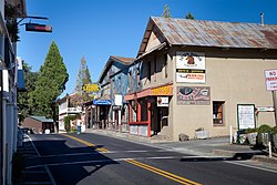
 Groveland California in 2012 | |
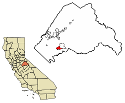
 Location of Groveland in Tuolumne County, California. | |
| Coordinates: 37°49′54″N 120°14′23″W / 37.83167°N 120.23972°W | |
| Country | |
| State | |
| County | Tuolumne |
| Area | |
• Total | 9.567 sq mi (24.779 km2) |
| • Land | 9.561 sq mi (24.764 km2) |
| • Water | 0.006 sq mi (0.015 km2) 0.06% |
| Elevation | 3,136 ft (956 m) |
| Population (2020) | |
• Total | 540 |
| • Density | 56/sq mi (22/km2) |
| Time zone | UTC-8 (Pacific (PST)) |
| • Summer (DST) | UTC-7 (PDT) |
| ZIP Code | 95321 |
| Area code | 209 |
| GNIS feature ID | 2628856 |
| U.S. Geological Survey Geographic Names Information System: Groveland, California | |
| Reference no. | 446 |
Groveland is a census-designated place (CDP) in Tuolumne County, California.[2] Groveland sits at an elevation of 3,136 feet (956 m).[2] The 2020 United States census reported Groveland's population was 540.[3]
Groveland was created as a CDP prior to the 2010 census; previously it was part of Groveland-Big Oak Flat CDP.
- ^ U.S. Census Archived 2012-01-25 at the Wayback Machine
- ^ a b c U.S. Geological Survey Geographic Names Information System: Groveland, California
- ^ Bureau, US Census. "Search Results". The United States Census Bureau. Retrieved November 11, 2021.
{{cite web}}:|last=has generic name (help)
