Grue Municipality
Grue kommune | |
|---|---|
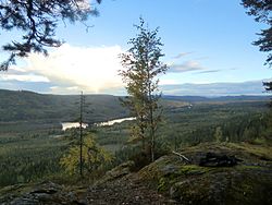
 View of the landscape in eastern Grue | |
 Innlandet within Norway | |
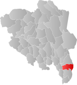
 Grue within Innlandet | |
| Coordinates: 60°27′23″N 12°03′30″E / 60.45639°N 12.05833°E | |
| Country | Norway |
| County | Innlandet |
| District | Solør |
| Established | 1 January 1838 |
| • Created as | Formannskapsdistrikt |
| Administrative centre | Kirkenær |
| Government | |
| • Mayor (2019) | Rune Grenberg (Ap) |
| Area | |
| • Total | 837.18 km2 (323.24 sq mi) |
| • Land | 777.54 km2 (300.21 sq mi) |
| • Water | 59.64 km2 (23.03 sq mi) 7.1% |
| • Rank | #136 in Norway |
| Population (2023) | |
| • Total | 4,572 |
| • Rank | #189 in Norway |
| • Density | 5.9/km2 (15/sq mi) |
| • Change (10 years) | |
| Demonym | Grusokning[1] |
| Official language | |
| • Norwegian form | Bokmål |
| Time zone | UTC+01:00 (CET) |
| • Summer (DST) | UTC+02:00 (CEST) |
| ISO 3166 code | NO-3417[3] |
| Website | Official website |
Grue is a municipality in Innlandet county, Norway. It is located in the traditional district of Solør. The administrative centre of the municipality is the village of Kirkenær. Other villages in the municipality include Bergesida, Grinder, Namnå, Risberget, Rotberget, Skasenden, and Svullrya.
The 837-square-kilometre (323 sq mi) municipality is the 136th largest by area out of the 356 municipalities in Norway. Grue is the 189th most populous municipality in Norway with a population of 4,572. The municipality's population density is 5.9 inhabitants per square kilometre (15/sq mi) and its population has decreased by 8.5% over the previous 10-year period.[4][5]
Economy: One private company (a lamp factory) has 51 employees; as of June 2024, there is less than a year until the production gets moved to an EU country.[6]
- ^ "Navn på steder og personer: Innbyggjarnamn" (in Norwegian). Språkrådet.
- ^ "Forskrift om målvedtak i kommunar og fylkeskommunar" (in Norwegian). Lovdata.no.
- ^ Bolstad, Erik; Thorsnæs, Geir, eds. (26 January 2023). "Kommunenummer". Store norske leksikon (in Norwegian). Kunnskapsforlaget.
- ^ Statistisk sentralbyrå. "Table: 06913: Population 1 January and population changes during the calendar year (M)" (in Norwegian).
- ^ Statistisk sentralbyrå. "09280: Area of land and fresh water (km²) (M)" (in Norwegian).
- ^ https://www.nrk.no/innlandet/hjornesteinsbedriften-bak-den-ikoniske-luxo-l-1-lampa-flagger-ut-fra-grue-til-polen-1.16934732. NRK.no. Retrieved 2024-06-22

