| Guadalupe River State Park | |
|---|---|
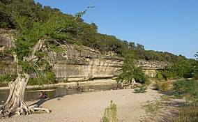
 A bluff in Guadalupe River State Park | |
| Location | Comal County / Kendall County, Texas |
| Nearest city | Bulverde |
| Coordinates | 29°52′29″N 98°30′16″W / 29.87472°N 98.50444°W |
| Area | 1,938.7 acres (785 ha) |
| Established | 1983 |
| Visitors | 238,841 (in 2022)[1] |
| Governing body | Texas Parks and Wildlife Department |
Guadalupe River State Park is a Texas state park located on a section of the Guadalupe River in Kendall and Comal Counties, northwest of Bulverde, Texas United States and is administered by the Texas Parks and Wildlife Department. The land was acquired by deed from private owners in 1974 and was opened to the public in 1983.[2]
670 acres of 1938.7 acre park is located on the north side of the river and is named the Bauer Unit, after the German couple that settled there in the mid-1800s. There are no amenities or facilities in the Bauer Unit just trails. The Bamberger Trail is named after J. David Bamberger, who sold most of the land that became the Bauer Unit to the State of Texas in 1974.[3]
- ^ Christopher Adams. "What is the most visited state park in Texas? Here's the top 10 countdown". KXAN.com. Retrieved November 21, 2023.
- ^ "Guadalupe River State Park". tpwd.texas.gov. Texas Parks and Wildlife Department. Retrieved January 7, 2023.
- ^ Bond, Courtney. "Going With the Flow at Guadalupe River State Park". texasmonthly.com. TexasMonthly. Retrieved January 7, 2023.

