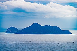
| Guishan (Gueishan) Island; Kueishan (Kweishan) Island | |
|---|---|
 | |
| Highest point | |
| Elevation | 361 m (1,184 ft)[1] |
| Prominence | 361 m (1,184 ft) |
| Coordinates | 24°50′31″N 121°57′06″E / 24.84194°N 121.95167°E |
| Dimensions | |
| Area | 2.841 km2 (1.097 sq mi) (prior to 2024)[2][3] |
| Geography | |
Philippine Sea, off the NE coast of Yilan, Taiwan | |
| Geology | |
| Rock age | Pleistocene |
| Mountain type | Stratovolcano |
| Last eruption | 1853 |
Guishan Island[4] / Gueishan Island[5] or Steep Island or Turtle Island[6] (Chinese: 龜山島; Hanyu Pinyin: Guīshāndǎo[3]; Tongyong Pinyin: Gueishandǎo; Wade–Giles: Kuei1-shan1-tao3; lit. 'Turtle Mountain Island'), also known as Kweishan Island or Kueishan Island, is an island in the Pacific Ocean, part of Toucheng Township, Yilan County, Taiwan[3] and located 9.1 km (5.7 mi) east of port of Kengfang Fishery Harbor. The island's name is derived from the resemblance of the topography of the island to that of a turtle.[3] The island is a dormant volcano that last erupted in 1785.
There is a smaller island south of Gueishan Island called Gueiluan Island (Chinese: 龜卵島; Hanyu Pinyin: Guīluǎndǎo; Tongyong Pinyin: Gueiluǎndǎo; Wade–Giles: Kuei1-luan3-tao3; lit. 'Turtle Egg Island').[7]
- ^ "Kueishantao". Global Volcanism Program. Retrieved 17 March 2023.
- ^ 龜山里. 宜蘭縣頭城鎮公所 Toucheng Township Office. Retrieved 19 October 2019.
全島面積2.841平方公里,
- ^ a b c d 教育部重編國語辭典修訂本 (in Chinese (Taiwan)). Retrieved 19 October 2019.
字詞 【龜山島】 注音 ㄍㄨㄟ ㄕㄢ ㄉㄠˇ 漢語拼音 guī shān dǎo 釋義 島名。位於宜蘭縣頭城鎮外海。為一火山島,屬頭城鎮管轄。周圍海岸線長八點七公里,面積二點八平方公里,以形狀似龜而得名。
- ^ "Guishan Island". Northeast and Yilan Coast National Scenic Area Tourist Information Website. 7 October 2019. Archived from the original on 29 June 2017. Retrieved 19 October 2019.
- ^ "Watch dolphins and whales". Northeast and Yilan Coast National Scenic Area Tourist Information Website. 1 July 2019. Archived from the original on 29 June 2017. Retrieved 19 October 2019.
The Gueishan Island is located off the coast of Yilan County, Taiwan.
- ^ Robert Kelly; Joshua Samuel Brown, eds. (March 2011). Taiwan. Lonely Planet (8 ed.). Singapore. p. 134. ISBN 9781741790436.
Turtle Island (Kueishgan [sic] Island) 龜山島
{{cite book}}: CS1 maint: location missing publisher (link) - ^ 05-19 臺灣島嶼面積 [Location and Area of Islands in Taiwan]. Ministry of the Interior (in Chinese (Taiwan) and English). Retrieved 20 October 2019.
縣市別 Locality 島嶼名稱 位置 Location 面積(平方公里) (1) 經度 緯度 Name of Islands Longitude Latitude Area (K m2){...}宜蘭縣 Yilan County{...}龜卵島 Gueiluan Island 121°55′47〞~121°55′51〞 24°48′30〞~24°48′32〞 0.0123
