| Gulf Intracoastal Waterway | |
|---|---|
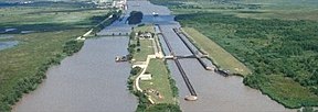
 Leland Bowman Lock near Intracoastal City, Louisiana, on the Gulf Intracoastal Waterway | |
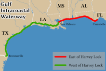
 The route of the Gulf Intracoastal Waterway | |
| Location | Gulf Coast of the United States |
| Country | United States |
| Specifications | |
| Length | 1,300[1] miles (2,100 km) |
| History | |
| Date completed | June 18, 1949 |
| Geography | |
| Start point | Brownsville, Texas |
| End point | Saint Marks, Florida[2] |
| Branch of | Intracoastal Waterway |
| Connects to | Various |
 | |
The Gulf Intracoastal Waterway (GIWW[1]) is the portion of the Intracoastal Waterway located along the Gulf Coast of the United States. It is a navigable inland waterway running approximately 1,300 mi (2,100 km)[1] from Saint Marks, Florida, to Brownsville, Texas.
The waterway provides a channel with a controlling depth of 12 ft (3.7 m), designed primarily for barge transportation. Although the U.S. government proposals for such a waterway were made in the early 19th century,[3] the Gulf Intracoastal Waterway was not completed until 1949.[4]
- ^ a b c Transportation Research Board 2004, p. 30.
- ^ US Army 2013.
- ^ Leatherwood, Art (15 June 2010). "Gulf Intracoastal Waterway". Handbook of Texas Online. Texas State Historical Association. Retrieved March 23, 2020.
- ^ Lynn M. Alperin. "History of the Gulf Intracoastal Waterway" (PDF). U.S. Army Corps of Engineers Office of History. Archived from the original (PDF) on 2005-12-08. Retrieved 2006-04-03.