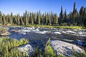
| Gulkana River | |
|---|---|
 Gulkana River | |
| Location | |
| Country | United States |
| State | Alaska |
| Census Area | Southeast Fairbanks, Valdez–Cordova |
| Physical characteristics | |
| Source | Summit Lake |
| • location | Alaska Range, Southeast Fairbanks Census Area |
| • coordinates | 63°14′29″N 145°28′03″W / 63.24139°N 145.46750°W[1] |
| • elevation | 3,806 ft (1,160 m)[2] |
| Mouth | Copper River |
• location | 9 miles (14 km) northeast of Glennallen, Valdez–Cordova Census Area |
• coordinates | 62°13′15″N 145°23′34″W / 62.22083°N 145.39278°W[1] |
• elevation | 1,302 ft (397 m)[1] |
| Length | 60 mi (97 km)[1] |
| Basin size | 2,140 sq mi (5,500 km2)[3] |
| Type | Wild 181.0 miles (291.3 km) |
| Designated | December 2, 1980[4] |
The Gulkana River[pronunciation?] is a 60-mile (97 km) tributary of the Copper River in the U.S. state of Alaska.[1] Beginning near the southeastern end of Summit Lake in the Alaska Range, the river flows generally south to meet the larger river 9 miles (14 km) northeast of Glennallen.[1] The Richardson Highway and the Trans-Alaska Pipeline run north–south, nearby and roughly parallel to the Gulkana River.[5] Slightly south of Summit Lake the river passes under the east–west Denali Highway near its junction with the Richardson Highway at Paxson.[5]
- ^ a b c d e f "Gulkana River". Geographic Names Information System. United States Geological Survey. January 1, 2000. Retrieved December 21, 2013.
- ^ Derived by entering source coordinates in Google Earth.
- ^ "Gulkana Wild and Scenic River". Bureau of Land Management. February 26, 2010. Archived from the original on December 24, 2013. Retrieved December 21, 2013.
- ^ "National Wild and Scenic Rivers System". rivers.gov. National Wild and Scenic Rivers System. Retrieved 2023-01-05.
- ^ a b Alaska Atlas & Gazetteer (7th ed.). Yarmouth, Maine: DeLorme. 2010. pp. 96–97, 106–07. ISBN 978-0-89933-289-5.
