Gunnison, Utah | |
|---|---|
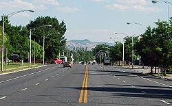
 Looking south down Gunnison's Main Street (US-89), June 2005 | |
 Location in Sanpete County and the state of Utah. | |
| Coordinates: 39°9′19″N 111°49′6″W / 39.15528°N 111.81833°W | |
| Country | United States |
| State | Utah |
| County | Sanpete |
| Founded | 1859 |
| Named for | John Williams Gunnison |
| Area | |
• Total | 4.79 sq mi (12.40 km2) |
| • Land | 4.79 sq mi (12.40 km2) |
| • Water | 0.00 sq mi (0.00 km2) |
| Elevation | 5,138 ft (1,566 m) |
| Population (2020) | |
• Total | 3,509 |
| • Density | 732.57/sq mi (282.85/km2) |
| Time zone | UTC-7 (Mountain (MST)) |
| • Summer (DST) | UTC-6 (MDT) |
| ZIP code | 84634 |
| Area code | 435 |
| FIPS code | 49-32660[3] |
| GNIS feature ID | 1428432[2] |
| Website | Official website |
Gunnison is a city in the Sevier Valley in southwestern Sanpete County, Utah, United States. The population was 3,509 at the 2020 census. The city was named in honor of John W. Gunnison, a United States Army officer who surveyed for the transcontinental railroad in 1853.[4]
- ^ "2019 U.S. Gazetteer Files". United States Census Bureau. Retrieved August 7, 2020.
- ^ a b U.S. Geological Survey Geographic Names Information System: Gunnison, Utah
- ^ "U.S. Census website". United States Census Bureau. Retrieved January 31, 2008.
- ^ Leigh, Rufus Wood (1961). Five hundred Utah place names: their origin and significance. Salt Lake City: Deseret News Press. p. 34.