| Gusinaya (Xaastaax) Гусиная / Хаастаах | |
|---|---|
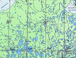
 Course of the Gusinaya ONC map section | |
Mouth location in Yakutia, Russia | |
| Location | |
| Country | Russia |
| Physical characteristics | |
| Source | |
| • location | Empe-Talalakh |
| • coordinates | 71°39′34″N 146°19′24″E / 71.65944°N 146.32333°E |
| • elevation | 26 metres (85 ft) |
| Mouth | East Siberian Sea |
• location | Gusinaya Bay |
• coordinates | 71°40′59″N 148°52′52″E / 71.68306°N 148.88111°E |
• elevation | 0 metres (0 ft) |
| Length | 278 km (173 mi) |
| Basin size | 5,980 km2 (2,310 sq mi) |
The Gusinaya (Russian: Гусиная; Yakut: Хаастаах, Xaastaax) is a river in the Sakha Republic (Yakutia), Russia. It has a length of 278 kilometres (173 mi) and a drainage basin area of 5,980 square kilometres (2,310 sq mi).[1]
The river flows north of the Arctic Circle, across territories of the Allaikhovsky District marked by permafrost. There are no settlements along its course, only some hunting huts.[2][3]
