Gwalior district | |
|---|---|
District | |
Clockwise from top-left: Jai Vilas Mahal, Tigra Dam, Gopachal Parvat, view of Gwalior from Gwalior Fort, Vishnu temple in Pawaya | |
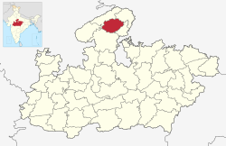
 Location of Gwalior district in Madhya Pradesh | |
| Country | |
| State | Madhya Pradesh |
| Division | Gwalior |
| Headquarters | Gwalior |
| Tehsils | 1. Gwalior, 2. Bhitarwar, 3. Dabra 4. Chinor 5. City Center 6. Ghatigaon 7. Morar |
| Government | |
| • Lok Sabha constituencies | Gwalior (shared with Shivpuri district) |
| • Vidhan Sabha constituencies | 1. Gwalior Rural, 2. Gwalior, 3. Gwalior East, 4. Gwalior South, 5. Bhitarwar and 6. Dabra |
| Area | |
| • Total | 4,560 km2 (1,760 sq mi) |
| Population (2011) | |
| • Total | 2,032,036 |
| • Density | 450/km2 (1,200/sq mi) |
| Demographics | |
| • Literacy | 77 per cent |
| • Sex ratio | 864 |
| Time zone | UTC+05:30 (IST) |
| Website | gwalior |
Gwalior district is one of the 52 districts of Madhya Pradesh state in central India. The historic city of Gwalior is its administrative headquarters. Other cities and towns in this district are Antari, Bhitarwar, Bilaua, Dabra, Morar Cantonment, Pichhore, and Tekanpur. The district is at the centre of the Gird region.
The district has an area of 4,560 km2, and a population 2,032,036 (2011 census), a 25% increase from the 2001 census. Kaushlendra Vikram Singh has been the district collector since March 2020.


