Gwernaffield
| |
|---|---|
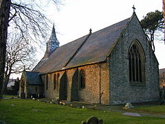
 Holy Trinity Church, Gwernaffield | |
Location within Flintshire | |
| Population | 1,942 (2011) |
| OS grid reference | SJ204644 |
| Community | |
| Principal area | |
| Preserved county | |
| Country | Wales |
| Sovereign state | United Kingdom |
| Post town | MOLD |
| Postcode district | CH7 |
| Dialling code | 01352 |
| Police | North Wales |
| Fire | North Wales |
| Ambulance | Welsh |
| UK Parliament | |
| Senedd Cymru – Welsh Parliament | |
Gwernaffield (Welsh: Y Waun),[1] is a village and electoral ward in Flintshire, Wales. It lies about three miles west of Mold on the eastern side of the Clwydian Range. The village is part of the community of Gwernaffield with Pantymwyn, which has an area of 7.53 km2 and is bordered by the River Alyn on three sides.[2] The community includes the neighbouring village of Pantymwyn and had a population of 1,851 at the time of the 2001 census,[3] increasing to 1,942 at the 2011 census.[4] The name of the village comes from gwern (Welsh for 'alder-grove'), feld (Old English for 'field') and gwaun (Welsh for 'moorland').[5] Gwernaffield, which adjoins Pantymwyn, Itself had a population of around 900. [6]
- ^ "Standardised Welsh Place names". www.welshlanguagecommissioner.wales. Retrieved 13 May 2023.
- ^ Davies, John; Nigel Jenkins, Menna Baines & Peredur I. Lynch (2008) The Welsh Academy Encyclopaedia of Wales, University of Wales Press, Cardiff.
- ^ Office for National Statistics (2004) Gwernaffield Community: Parish Headcounts Archived 11 December 2015 at the Wayback Machine. Accessed 3 April 2012.
- ^ "Community/Ward population 2011". Retrieved 23 May 2015.
- ^ Owen, Hywel Wyn & Richard Morgan (2007) Dictionary of the Place-names of Wales, Gomer Press, Llandysul, Ceredigion.
- ^ UK Census (2011). "Local Area Report – gwernaffield population (W37000300)". Nomis. Office for National Statistics. Retrieved 30 May 2022.
