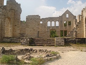
| Ha Ha Tonka State Park | |
|---|---|
 The "castle" ruins at Ha Ha Tonka | |
| Location | Camden County, Missouri, United States[1] |
| Coordinates | 37°58′08″N 92°46′09″W / 37.96889°N 92.76917°W[2] |
| Area | 3,751.74 acres (15.1828 km2)[3] |
| Elevation | 705 ft (215 m)[2] |
| Established | 1978[4] |
| Visitors | 543,406 (in 2017)[3] |
| Operator | Missouri Department of Natural Resources |
| Website | Ha Ha Tonka State Park |
Ha Ha Tonka State Park is a public recreation area encompassing over 5,000 acres (2,000 ha) on the Niangua arm of the Lake of the Ozarks, about five miles south of Camdenton, Missouri, in the United States. The state park's most notable feature is the ruins of Ha Ha Tonka, an early 20th-century stone mansion that was modeled after European castles of the 16th century.
The park also features caves, sinkholes, and bluffs overlooking the lake. It is a prominent example of karst topography, which is geological formation shaped by the dissolution of a layer or layers of soluble bedrock.[5] A 70-acre (28 ha) portion of the park was designated as the Ha Ha Tonka Karst Natural Area in 1981.[6]
- ^ Cite error: The named reference
parks2was invoked but never defined (see the help page). - ^ a b "Ha Ha Tonka State Park". Geographic Names Information System. United States Geological Survey, United States Department of the Interior.
- ^ a b Cite error: The named reference
parkdatawas invoked but never defined (see the help page). - ^ Cite error: The named reference
acquisitionwas invoked but never defined (see the help page). - ^ Cite error: The named reference
parkswas invoked but never defined (see the help page). - ^ Cite error: The named reference
naturalareaswas invoked but never defined (see the help page).

