| Haberfield Sydney, New South Wales | |||||||||||||||
|---|---|---|---|---|---|---|---|---|---|---|---|---|---|---|---|
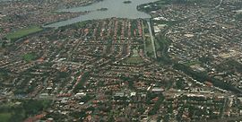
 Aerial photograph of Haberfield | |||||||||||||||
 | |||||||||||||||
| Population | 6,480 (SAL 2021)[1] | ||||||||||||||
| Postcode(s) | 2045 | ||||||||||||||
| Elevation | 21 m (69 ft) | ||||||||||||||
| Location | 6.4 km (4 mi) west of Sydney CBD | ||||||||||||||
| LGA(s) | Inner West Council | ||||||||||||||
| State electorate(s) | Summer Hill | ||||||||||||||
| Federal division(s) | Grayndler | ||||||||||||||
| |||||||||||||||
Haberfield is a suburb in the Inner West[2] of Sydney, in the state of New South Wales, Australia. Haberfield is located 6.5 kilometres west of the Sydney central business district in the local government area of the Inner West Council.
Haberfield sits south of Iron Cove, which is part of Sydney Harbour. It is bounded to the east by the Hawthorne Canal, to the northwest by the Iron Cove Creek canal and to the southwest by Parramatta Road. Its main road is Ramsay Street and the point of land that faces Iron Cove, Dobroyd Point, is a historical locality of Sydney. Haberfield was dubbed "the garden suburb" in the early 20th century and retains its well-kept parks, tree-lined streets and fine Federation-era houses with immaculate gardens. The entire suburb is heritage-listed. It is also known for its Italian culture.
- ^ Australian Bureau of Statistics (28 June 2022). "Haberfield (suburb and locality)". Australian Census 2021 QuickStats. Retrieved 28 June 2022.
- ^ Australian Suburb Guide: Sydney Inner West Archived 26 December 2012 at the Wayback Machine Retrieved 8 August 2013.