This article needs additional citations for verification. (September 2016) |
Hachijojima Airport 八丈島空港 Hachijōjima Kūkō | |||||||||||
|---|---|---|---|---|---|---|---|---|---|---|---|
 | |||||||||||
| Summary | |||||||||||
| Airport type | Public | ||||||||||
| Operator | Tokyo Municipal Government | ||||||||||
| Serves | Hachijōjima, Japan | ||||||||||
| Elevation AMSL | 301 ft / 92 m | ||||||||||
| Coordinates | 33°06′54″N 139°47′09″E / 33.11500°N 139.78583°E | ||||||||||
| Map | |||||||||||
 | |||||||||||
| Runways | |||||||||||
| |||||||||||
| Statistics (2015) | |||||||||||
| |||||||||||
Source: Japanese AIP at AIS Japan[1] Japanese Ministry of Land, Infrastructure, Transport and Tourism[2] | |||||||||||
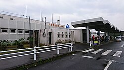
Hachijojima Airport (八丈島空港, Hachijōjima Kūkō) (IATA: HAC, ICAO: RJTH) is a regional airport serving Hachijōjima in the southern Izu Islands, Tokyo, Japan.
- ^ AIS Japan Archived 2016-05-17 at the Portuguese Web Archive
- ^ "Hachijojima Airport" (PDF). Japanese Ministry of Land, Infrastructure, Transport and Tourism. Archived from the original (PDF) on 21 October 2016. Retrieved 7 January 2017.
