Hackberry, Arizona | |
|---|---|
 Welcome to Hackberry | |
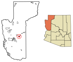
 Location in Mohave County, Arizona | |
| Coordinates: 35°22′09″N 113°43′38″W / 35.36917°N 113.72722°W | |
| Country | United States |
| State | Arizona |
| County | Mohave |
| Founded | 1874 |
| Area | |
• Total | 17.59 sq mi (45.56 km2) |
| • Land | 17.59 sq mi (45.56 km2) |
| • Water | 0.00 sq mi (0.00 km2) |
| Elevation | 3,583 ft (1,092 m) |
| Population | |
• Total | 103 |
| • Density | 5.9/sq mi (2.26/km2) |
| Time zone | UTC-7 (Mountain (MST)) |
| ZIP code | 86411 |
| Area code | 928 |
| GNIS feature ID | 5466[3] |
| FIPS code | 04-30830 |
| Part of a series of the |
| Cities, towns and CDPs in Arizona with lists and images of historic properties, forts, cemeteries or historic districts |
|---|
Hackberry is an unincorporated community and census-designated place (CDP) in Mohave County, Arizona, United States. It is located on Arizona State Route 66 (former U.S. Route 66) 28 miles (45 km) northeast of Kingman. Hackberry has a post office which as of 2015 served 68 residential mailboxes with ZIP code 86411.[4] As of the 2020 census, Hackberry had a population of 103.[2]
- ^ "2021 U.S. Gazetteer Files: Arizona". United States Census Bureau. Retrieved May 23, 2022.
- ^ a b "P1. Race – Hackberry CDP, Arizona: 2020 DEC Redistricting Data (PL 94-171)". U.S. Census Bureau. Retrieved May 23, 2022.
- ^ U.S. Geological Survey Geographic Names Information System: Hackberry, Arizona
- ^ "Free ZIP Code Lookup with area code, county, geocode, MSA/PMSA, population". zipinfo.com. Retrieved March 8, 2015.


