Hailakandi district | |
|---|---|
| Hailakandi | |
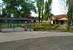
 Kendriya Vidyalaya, Panchgram | |
 Location in Assam | |
| Country | |
| State | Assam |
| Division | Barak Valley |
| District created | 1 October 1989 |
| Government | |
| • Lok Sabha constituencies | Karimganj (shared with Karimganj district) |
| • Vidhan Sabha constituencies | Hailakandi, Katlicherra, Algapur |
| Area | |
• Total | 1,327 km2 (512 sq mi) |
| Elevation | 21 m (69 ft) |
| Population (2011)[1] | |
• Total | 659,296 |
| • Density | 497/km2 (1,290/sq mi) |
| Demonym(s) | Hailakandian, Hailakandiya |
| Time zone | UTC+5:30 (IST) |
| PIN | 78815X |
| Telephone code | 91 – (0) 3844 |
| ISO 3166 code | IN-AS |
| Vehicle registration | AS-24 |
| Official language | Bengali |
| Associate official language | Meitei (Manipuri) |
| Website | hailakandi |
Hailakandi district is one of the 33 districts of Assam state in north-eastern India. It makes up the Barak Valley alongside Cachar and Karimganj. It was constituted as a civil subdivision on 1 June 1869. Subsequently, it was upgraded to a district in 1989, when it was split from Cachar district.[2]
- ^ Cite error: The named reference
districtcensuswas invoked but never defined (see the help page). - ^ Law, Gwillim (25 September 2011). "Districts of India". Statoids. Retrieved 11 October 2011.