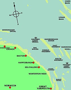
Haisborough Sands
Haisboro Sands or Haisbro Sands | |
|---|---|
 Location map of Haisborough Sands | |
| Coordinates: 52°54′N 1°42′E / 52.900°N 1.700°E | |
| Location | Southern North Sea, United Kingdom |
| Area | |
| • Total | 31.249 km2 (12.065 sq mi) |
| Dimensions | |
| • Length | 16 km (9.9 mi) |
| • Width | 1.6 km (0.99 mi) |
Haisborough Sands (or Haisboro Sands or Haisbro Sands) is a sandbank off the coast of Norfolk, England at Happisburgh.[1] The shoal is 10 miles (16 km) long and 1 mile (1.6 km) wide and lies parallel to the north-east coast of Norfolk. The shoal is marked to the northwest by north by the Haisbro Light Buoy, North cardinal. To the southeast by south is a light buoy South cardinal, and to the west by Mid Haisbro light buoy starboard hand. In 1995 there were three drying patches[clarification needed] recorded to the north-northeast and east-southeast of the Mid Haisbro light buoy. Except at slack water their positions are indicated by tidal eddies particularly on the northwest, and in slight or moderate seas the swell breaks on the shallower parts of the banks. There are several foul patches[clarification needed] on the southern part of the shoal. Over the years this shoal has claimed many ships.[2]