| Halcott Mountain | |
|---|---|
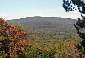
 Halcott from Belleayre Ski Center to the south | |
| Highest point | |
| Elevation | 3520+ ft (1073 m)+ NGVD 29[1] |
| Prominence | 700 ft (210 m)[1] |
| Listing | Catskill High Peaks #32 |
| Coordinates | 42°10′48″N 74°26′17″W / 42.1800882°N 74.4379281°W[2] |
| Geography | |
| Location | Lexington, New York, United States |
| Parent range | Catskill Mountains |
| Topo map | USGS West Kill |
| Geology | |
| Rock age | 250-350 mya |
| Mountain type | Dissected plateau |
| Climbing | |
| Easiest route | Hike up east slope from NY 42 to summit ridge |
Halcott Mountain is one of the Catskill Mountains of the U.S. state of New York. It is mostly located in Greene County, with some of its lower slopes in Delaware and Ulster counties. Its exact summit elevation has not been officially determined, but the highest contour line on the mountain is 3,520 feet (1,070 m). It is one of the peaks on the divide between the Delaware and Hudson watersheds.
As one of the Catskill High Peaks above 3,500 feet (1,100 m) in elevation, a successful ascent of Halcott is required for peakbaggers seeking to join the Catskill Mountain 3500 Club. It is on public land, part of the Catskill Park Forest Preserve, but has no trail. Hikers bushwhack through the relatively open woods to sign the canister at the summit and prove their climb. It is considered one of the easiest of the 13 trailless High Peaks.[3]
- ^ a b "Halcott Mountain, New York". Peakbagger.com. Retrieved 2010-05-17.
- ^ "Halcott Mountain". Geographic Names Information System. United States Geological Survey, United States Department of the Interior. Retrieved 2010-05-17.
- ^ "Halcott Mountain 3537'". Catskill Mountain 3500 Club. 2007–2010. Retrieved February 1, 2010.

